Site location and context
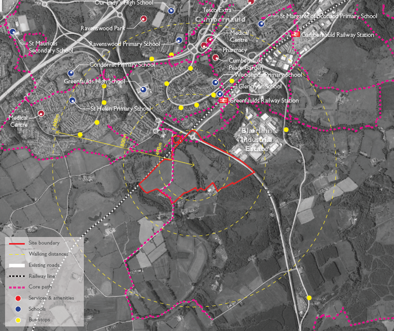
The site is located to the south west of Cumbernauld town centre, to the west of the A73. It is well located for access to local services and amenities, including sustainable modes of transport.
Greenfaulds Railway Station is located to the north east of the site, around 800m from the centre of the site. Cumbernauld Railway Station is also located to the north east, just over 1,600m from the centre of the proposals. Bus services are available to the north of the site, around 800m from the centre of the proposals. There is also the potential for bus services to be extended into the site, which would benefit both the residential, and employment proposals.
A number of schools are located to the north of the site. Woodlands Primary School is located to the north of the site, just over 800m walking distance from the centre of the site. Greenfaulds High School is located to the north west, around 1,000m from the centre of the site. For denominational schools, St Helens Primary School and St Maurices Secondary School are located to the north west of the site. The proposed new neighbourhood centre could also provide a potential location for a new primary school, subject to discussions with the Council.
The Core Path network is easily accessible from the site, with a Core Path being located along Summerhill and Garngibbock Road. This provides easy access to the wider path network to the north, connecting into Cumbernauld and the countryside to the south of the site.
Services and amenities are located within Cumbernauld, including supermarkets, medical centres, pharmacies and parks. The site also offers the opportunity to create new services and amenities through the creation of a new neighbourhood centre, serving new homes as well as the local area. This is in line with the Scottish Government’s focus on creating 20 minute neighbourhoods.


