Site Considerations
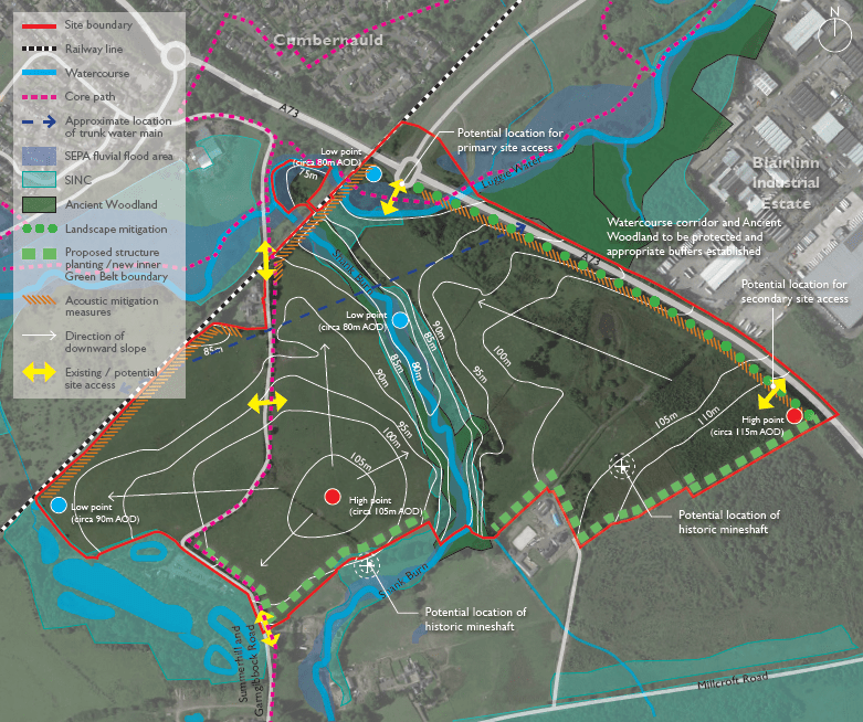
An existing roundabout to the north of the site boundary, located on the A73, provides the opportunity to provide an access into the site. There may also be scope to include a second point of access to the south of the site from the A73. Summerhill and Garngibbock Road passes through the site, offering further access into the site from the north.
A railway line runs parallel with the north western boundary. This area may require acoustic mitigation measures to protect amenity of new homes. Acoustic mitigation may also be required along the boundary adjacent to the A73.
The site generally falls from the south to the north, with two high points identified. This results in a number of low points within the site to the west and along the watercourse corridors. SuDS basins will be located at low points to ensure that the site drains at greenfield levels and discharged to watercourses at greenfield rates.
The Luggie Water and Shank Burn run through the site. The Shank Burn corridor is also the location of a Site of Importance for Nature Conservation (SINC) and an area of Ancient Woodland. This area will be protected from development and retained to ensure the protection of wildlife and habitats. An appropriate buffer will be established and agreed with the Council.
The Coal Authority mapping identifies two potential mineshafts located within or adjacent to the site boundary. Ground investigations will identify any mineshafts and appropriate mitigation measures will be established. A trunk water main is located in the northern half of the site. An appropriate stand off to the pipe will be established to meet with regulations and Council requirements.
The site is currently Green Belt but offers the opportunity to establish new and robust inner Green Belt boundaries. This could be provided in the form of structure planting, creating a clear boundary to the south.


