Site Location and Context
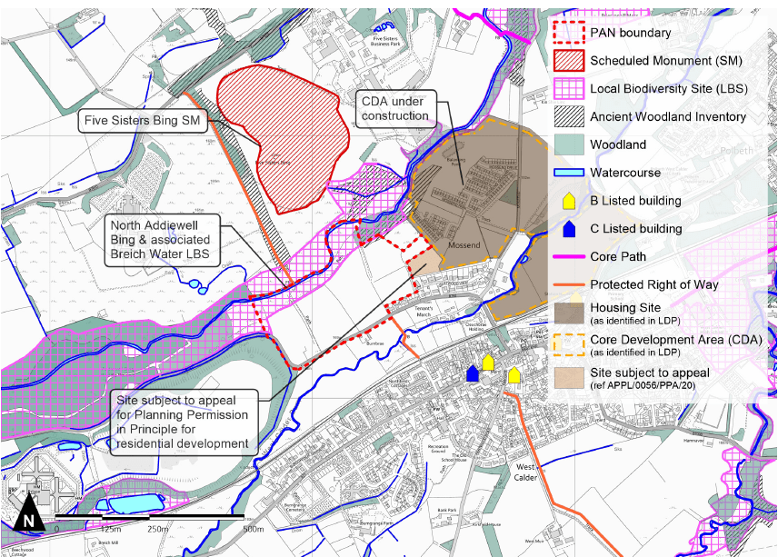
The site extents to around 18.7 ha, and is located approximately 400m north of the centre of West Calder on the north side of the B792. The land currently comprises fields of farmland, divided by hedgerows and tree belts as well as part of the Breich Water riparian corridor. Existing boundaries are largely hedgerows, and post and wire fences. This land is designated as Countryside Belt in the LDP. The layout of the proposal will be designed to form an appropriate countryside boundary to Mossend.
The North Addiewell Bing & associated Breich Water Local Biodiversity Site (LBS) runs along the northern boundary of the site. No development will be located within this LBS. There is an opportunity to enhance the biodiversity of the riparian corridor through new planting.
The Five Sisters Bing Scheduled Monument (SM) is located to the north of the site. An appropriate design response and landscape strategy will be incorporated into the proposal to ensure no adverse effects on this SM. This will be confirmed through further appraisals as the site progresses.
A Core Development Area for housing as identified in the LDP is located to the east of the site. This is currently under construction. Planning Permission in Principle (PPP) for residential development was also previously sought on the field to the east of the site. This is currently subject to planning appeal. The site presents an opportunity to provide a logical continuation of this pattern of development.
Protected Rights of Way (RoW) are located on the northern and southern boundaries of the site. These provide recreational access to the countryside and to West Calder. Development of the site presents an opportunity to provide connections between these Rights of Way.